A common man marvels at uncommon things. A wise man marvels at the commonplace. CONFUCIUS
Showing posts with label Peak District. Show all posts

Tuesday, 27 October 2015

Chatsworth

A dull, grey but magnificently autumnal day in Derbyshire's Peak District. This is the river Derwent . . .

. . . here running placidly by Chatsworth House, home to the Duke and Duchess of Devonshire. Chatsworth is one of England's finest stately homes. On the right you can see the Emperor Fountain, designed by Joseph Paxton in 1844. This was a massive construction project, and involved the creation of a lake on high ground behind the garden to supply the water pressure. It was finished in only six months. It was built for the impending visit of Tsar Nicholas I of Russia, but in the end he never came. In its day this was the world's highest fountain; in the photo it's only at minimal flow.

Chatsworth House between two oak trees in seasonal foliage.
Behind these splendid copper-leaved trees lies James Paine's Three Arch Bridge . . . 

. . . based on a Roman design.

Looking back at the river Derwent and the Chatsworth estate . . .

Leaving Chatsworth through Stand Wood, we approached a gate leading to a moorland access path . . .

. . . from where we admired this superb view across the Derwent valley . . . 

Friday, 4 July 2014

A Walk In The White Peak

The Peak District has two distinct areas and personalities: the Dark Peak in the north, which is all about cloughs and groughs, moorland and millstone grit; and the White Peak in the south, with its softer landscape of limestone villages and dales, of crystal-clear rivers and streams. This geological yin-yang aspect to the National Park creates a satisfying contrast and complementarity. Last week I walked on the wild side in the Dark Peak; yesterday, in the White Peak, I explored my more feminine side. I began my walk in the village of Hartington, which lies by the exquisitely-named River Dove.  

In the woodland of Beresford Dale butterbur grew tall between path and river. Other plants included buttercup and herb-robert and, growing in the river itself, water-crowfoot.

Wooden footbridges hardly ever fail to seduce me. However, I resisted the charms of this one, which led into Wolfscote Dale. I remembered I'd crossed it before — 25 years ago. Instead, I left the river and climbed gently up the dry valley of Narrow Dale. I don't think many walkers come here, and I had only wheatears and redstarts for company.

On the limestone plateau above the dale some field paths and a quiet road took me to the sleepy village of Alstonefield.

The pub was not yet open, but I was content to eat my sandwiches and drink from my flask of coffee on a bench on the village green. (Sandwich filling: egg, onion and cheddar cheese mayonnaise — an absolute favourite!)

Leaving Alstonefield and its stone, slate-roofed cottages, I followed a delightful path — lined with a multitude of wild flowers such as the bright-blue meadow crane's-bill — to the top of Gipsy Bank.

Here Coldeaton Dale joins Biggin Dale. 

I thought the view from the top of the bank was very fine. You can see Coldeaton Bridge below — and that's the river Dove again.

The meandering riverside path eventually led me to the head of Biggin Dale, where a foot and cycle-way curved over the hill and back to Hartington.

This is Hartington Hall. A country gentleman's retreat, you might think — or perhaps a five-star hotel? No, not at all. It's a youth hostel! Could this be the most beautiful youth hostel in the world? And it's got a bar . . .

It had been a really great walk, and it was with reluctance I left this limestone paradise. The Peak District is the National Park I know the best: for long periods of my life I've lived in Staffordshire, Lincolnshire and Nottinghamshire — all within easy reach of this outstanding, lovely region.

Thursday, 26 June 2014

A Walk In The Dark Peak

Old Meg she was a Gipsy,
       And liv'd upon the Moors:
Her bed it was the brown heath turf,
       And her house was out of doors.

Her apples were swart blackberries,
       Her currants pods o' broom;
Her wine was dew of the wild white rose,
       Her book a churchyard tomb.

Her Brothers were the craggy hills,
       Her Sisters larchen trees —
Alone with her great family
       She liv'd as she did please.

JOHN KEATS Meg Merrilies

Yesterday it took me two hours to drive to the Peak District — England's first National Park and my nearest National Park. In the past it used to take me an hour and a half. Now there seems to be twice as much traffic on the road. But that's progress for you. Well, no, not progress in an a temporal or kinetic sense. More a sort of dubious, materialistic progress — the kind of progress where every family now has not one car, but two, three or four, and the kind of progress where Internet shopping has flooded even the country by-roads with trucks and delivery vehicles to saturation point. In a bid to escape the traffic queues, the noise, the pollution, the CCTV cameras, the adverts, the signage, the street furniture, any old goddam furniture, Wimbledon and the World CupI parked my car with relief near Birchen Clough on the Snake Road and tumbled out and down into the cool woodland below. Now I could breathe again, though I could still hear the rumble of lorries and roar of motor bikes coming from the road above . . . 


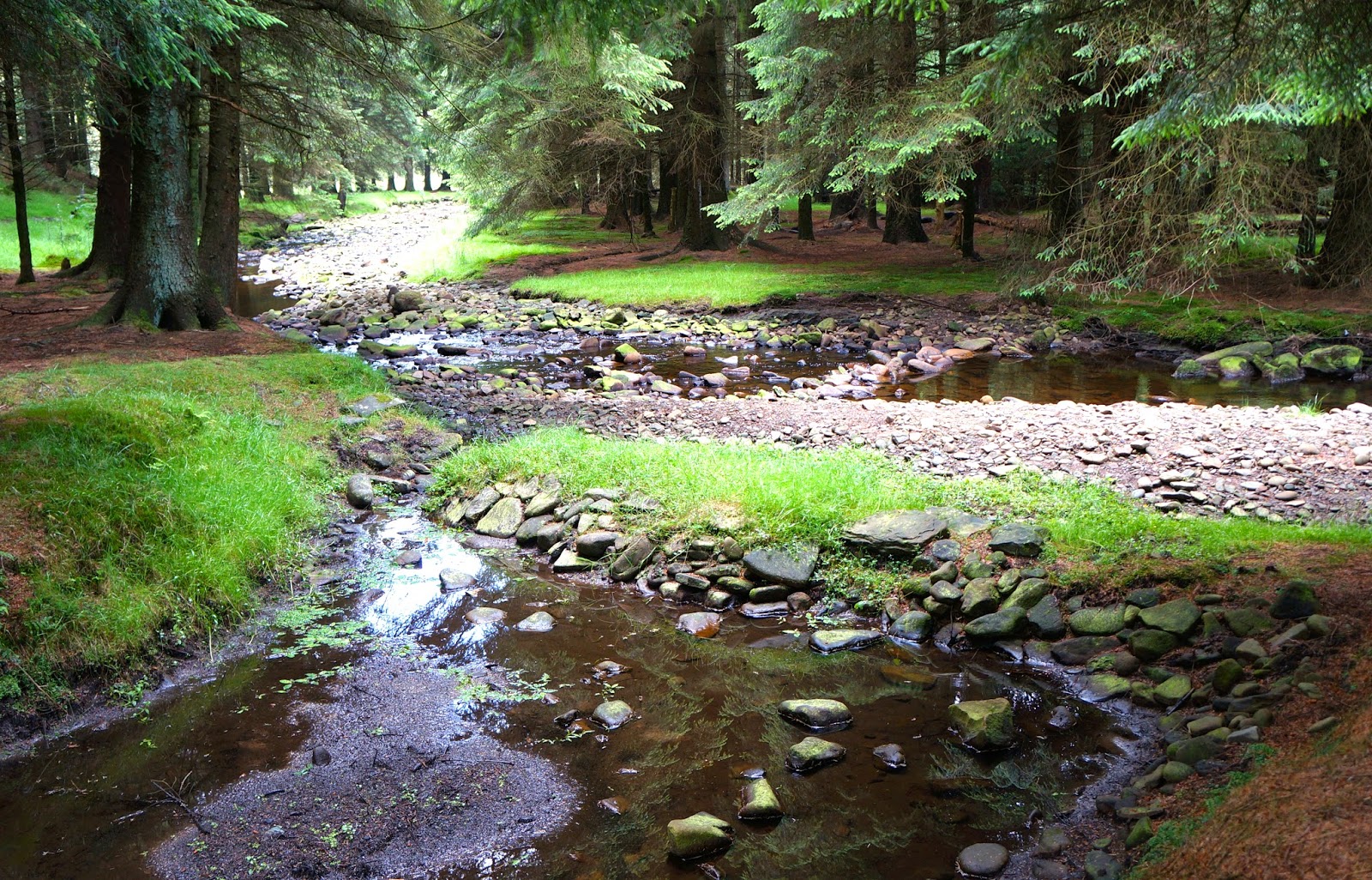
Here, in Lady Clough, the only 'furniture' was tree trunk, grassy bank and mossy stone...


. . . with the occasional simple and functional (and beautiful) man-made footbridge.


I relaxed, took stock — and realised with a gasp I'd have to gain the heights on the right . . .


But first here's the low-lying river Ashop . . .


. . . and here are some lovely and practical stone sheepfolds . . .


. . . which I passed before taking the steepening path along Fair Brook to the northern edge of the Kinder plateau. This was a magical valley of oak and rowan, heather and bracken, waterfall and rock.


The walking was tough, but the views made it all worthwhile.


The stream dried up when squeezed between ever-narrower and more contorted slabby outcrops . . .


I finally arrived at Fairbrook Naze (note the two ravens in the photo — a happy accident) . . .


. . .  where the moorland prospect was just awe-inspiring. This was the view from my lunchtime picnic spot. Was there ever a better one? A little wild and desolate, perhaps — but, my God, no cars, no litter, no factories, no chimneys, no wind farms, no pylons, no people, no obvious wars and conflicts. And I'd even turned my phone off, so social media were history.  


The gritstone rocks and boulders along this lofty edge had been worn into some fantastical shapes.


Before climbing down to join the Snake Path (which led me, interminably and sometimes soggily, from the source of the river Ashop back to my car), I took one last look back at the high-level, rocky route I'd just traversed . . .

Thursday, 8 April 2010

Lathkilldale


I've been going to the Peak District for as long as I can remember. It's the nearest National Park to here - with the most wonderful walks and scenery. It lies mainly in Derbyshire, but the western moorland edge takes in parts of Staffordshire and Cheshire too. Geologically it forms two distinct areas: the White Peak, a limestone plateau scored with deep river valleys, and the Dark Peak, an altogether different region of grits and shales, of rocky escarpments and acidic peat moorlands. I can't decide which I half I prefer, for I love them both.

Easter Sunday found me at the head of Ricklow Dale just outside the village of Monyash in the White Peak. This nine mile walk, from Ricklow Dale through Lathkilldale, down Bradford Dale, then across the limestone plateau back to Monyash, is an old favourite of mine. I've done it in all seasons and all weathers. Who could resist the inviting allure of this grassy, lumpy valley, as it winds out of sight through the gorge - becoming steeper and narrower, rockier and more wooded all the time? It draws you in...


Lathkilldale is special, a jewel among Derbyshire rivers, its waters crystal clear, its habitat perfect for orchids and the rare Jacobs Ladder flower, grey wagtails and dippers, water voles and brown trout. As the dale narrows, the open sides give way to steep slopes dense with ash trees, the young ash saplings with smooth, grey barks, the older trees with fissured trunks. Low by the stream the trees and rocks are covered in bright green moss and lichens. Further down there's a natural waterfall, then some man-made weirs with trout pools, and the relics of an old lead mine, the Mandale Mine.


Here's what Patrick Monkhouse has to say about the Lathkill in his book On Foot In The Peak, published in the 1930s, and one of my favourite books on the area (I like these old, little-known, out-of-print books brimming with personal enthusiasms, quirky observations and individual style - far more interesting than all the anodyne, clichéd guide books you find on sale everywhere):

The Lathkill should emerge from a great square cavern on the right as you go down Ricklow Dale. In wet weather it does so, and no river in the Peak has a more imposing birth. It springs, already a river, from the hillside, as the goddess Athene sprang fully armed from the head of Zeus. In dry weather, the Lathkill gets up late, and comes out, with perfunctory apologies, anything up to half a mile down its course. But one cannot long be angry with so beautiful a river. Lathkill is among the deepest and narrowest of the Derbyshire dales...

Here's the cave at Lathkill Head, where the river Lathkill emerges from the Underworld, and which Monkhouse describes so romantically...


(I've written before about Lathkilldale here.)

Tuesday, 19 February 2008

Zen And The Art Of Walking


Apart from a few local walks, and a walk in Sherwood Forest, I haven't been out walking much this year. But a few weeks ago I did take a trip to the Derbyshire Peak District. I parked the car in Miller's Dale (OS Outdoor Leisure Map 24, Map Reference 142733). I went under the old railway, now a walkers' and cyclists' path called the Monsal Trail (1st pic), passed these terraced cottages (2nd pic) and turned up the riverside path by the bridge (3rd pic).

The river Wye was in spate. The going was slippery and needed concentration. In the limestone gorge of Cheedale the valley narrowed and the rocks closed in. The path disappeared beneath the water. So I scrambled steeply up the northern bank along a vague track which became fainter and fainter - then petered out. I was now high above the gorge. The lip at the top, just below a drystone wall and some farmers' fields, was the steepest bit - and treacherous too. I slipped and slid muddily on last year's leaves. I was forced to grasp branches, roots and rocks in order to pull myself up to the wall. I skirted the edge of the gorge for a while along the merest hint of a path. Reverberating explosions came from the limestone quarry in Great Rocks Dale nearby. Weary of having to concentrate so hard to prevent myself falling over, I followed a field edge which took me to a proper track and public right of way at Mosley Farm. Immediately an old pony track zigzagged back down into Cheedale.

I trudged for a time along part of the old railway trackbed of the Monsal Trail, then down to the river itself - but once again the path proved impassable. The stepping stones you would normally skip over at the foot of a hollowed-out limestone cliff were completely submerged - and I didn't fancy wet feet and legs on this cold day. I changed plan and headed south-east out of the valley towards the hamlet of Blackwell - steeply at first, then more gently. Suddenly I relaxed and started to enjoy the walk properly for the first time. The weather had been dull, cold and grey. But it hadn't rained - and now, in the early afternoon, it was even brightening up a little. I thought not for the first time how the enjoyment of a walk is really just an attitude of mind. The frustrations I'd encountered, I realized, were essential prerequisites for my enjoyment now. If you can overcome negative thoughts about dismal weather, the annoyance at having to change your route plans, tumbling over in the mud and so on, a window in your mind can suddenly open, and you may enjoy things much more than you would have thought possible on such an unpromising day. Zen and the Art of Walking?

Anyway I sailed back down to my starting point. The last section followed the minor road through Blackwell Dale. This was an easy finish - though not as easy as you might expect, as cars and vans sped by a little too close for comfort. I also noted with sadness how much litter, thrown from car windows, lay strewn by the roadside.

Sunday, 23 September 2007

Mugged By Sheep

On all my countryside escapades I've never once been mobbed by nesting terns or attacked by arctic skuas like Bill Oddie. Or even bitten by a dog or chased by a bull. But I have been mugged by sheep. It happened yesterday in fact.

I began my 7 mile route on a minor road at Townhead just north of Hope (OS Outdoor Leisure Map 1, Map Reference 168845). This led north to Oaker Farm Cottages where it became a path. After crossing Bagshaw Bridge the way contoured the hillside overlooking Jaggers Clough then forked right just below Crookstone Barn. Another right turn at a stile and the path doubled back on itself at higher altitude. It was now a rutted old Roman road heading south-east above the conifer slopes of the Woodlands Valley. Lose Hill (476m) was constantly in view across the Vale of Edale; but I was making for its companion, Win Hill (462m). A long, easy ascent took me to the rocky cone on top, two paragliders adding interest along the way. It was here the marauding sheep stepped in.

I'd found a nice, sheltered spot for lunch among the rocks and heather. Everything was laid out - tomatoes, dried apricots, wholemeal rolls stuffed with Camembert... Then they hit. An evil-looking ewe, with her smaller but powerfully built offspring, ambushed me from out of a fortification of ferns. Their eyes were fixed and staring. Only one goal was on their mind. My sandwiches. And my camera, mobile phone, and complete rucksack contents if they were lucky. I was so surprised that I half rose and said something like "Shoo!" They were unimpressed by this resistance tactic and still charged on. It then got physical as they knocked me over. I tried to push them away but they were incredibly hard and strong.

I still don't know how I did it, but I managed in an adrenaline-fuelled rush of speed to gather up lunch and pack and camera into my arms - at one point wresting the nose of one sheep out of my open sack - and beat a hasty retreat off the hill. I decided on reflection that it wasn't really a case for the MRT - after all I was alive and in one piece and had lost only a few mouthfuls of French cheese (haven't Derbyshire sheep got upmarket tastes?)

The photo shows my ancient Karrimor daysack next to the trig point at the summit of Win Hill. Thankfully with not a sheep in sight.

Saturday, 22 September 2007

Pork With Prunes

Just back from another couple of days in Derbyshire's Peak District. Thursday evening found me pitched at Fieldhead Campsite, Edale. And in the Old Nag's Head. Sweet memories of when I'd started out from here in April to walk the Pennine Way. On Friday I did a couple of slow saunters.

The first was in the Hope Valley, separated from the Vale of Edale by the lovely Mam Tor - Lose Hill ridge. I simply walked from Castleton to Hope by field paths to the north, and returned by field paths to the south along a tributary of the river Noe, an easy clockwise circular of 4 miles. I stopped for a chat in Hope with the manager of the climbing shop, Hitch n Hike, a small satellite of the much bigger outlet at Mytham Bridge. He'd been a lecturer in electronics and also chef-manager on a steam train restaurant in Matlock (but not at the same time - at least, I don't think so!). How nice to have had such a varied path in life. He was crazy about French cooking and gave me a recipe for pork with prunes marinaded in Vouvray. Sounded good at the time - particularly as I hadn't eaten all day! Nice deli next door to the climbing shop, incidentally.

It had poured down with rain for almost an hour on the walk back to Castleton so I tried drying things out at the Edale campsite. But a 5 o'clock sky promised a fine evening, so I couldn't resist setting out again - this time directly from the tent south-west to Barber Booth; across the railway, road and river; then up, on a reasonably gentle slanting path, to Hollins Cross, the centrepoint of the Mam Tor ridge. I came back down to Edale via Backtor Bridge and Ollerbrook Booth. This had been an anti-clockwise circular of 5 miles.

The photo shows the Vale of Edale from the path up to Hollins Cross.

Wednesday, 19 September 2007

On The Edge


Yesterday at 10.40am I decided on impulse to snatch a dry, sunny afternoon from the jaws of autumn. I packed my ancient Karrimor daysack with waterproofs, water bottle, flask of tea, two cheese and lettuce sandwiches, two oatmeal biscuits, two fresh peaches, hat and gloves, map and compass, and Victorinox multi-feature Swiss Army Knife. No, it wasn't a mercenerary expedition. Merely a quick raid on the Derbyshire countryside. By 11.40 I was off, and at 1 o'clock exactly had parked at Curbar Gap (OS Outdoor Leisure Map 24, Map Reference 263747). Up on the gritstone escarpment of Curbar Edge the views westward were very fine (the 1st photo was taken from the Edge looking down on the villages of Curbar and Calver in the valley of the river Derwent. The abandoned millstone is a reminder that the manufacture of millstones used to be a thriving industry in this area.) Climbers were out in force (see 2nd and 3rd photos) and a few walkers too. An obvious path led along Froggatt Edge and down through Hay Wood to Nether Padley. Stonechats darted across the way and bobbed their heads on nearby rocks. There was a feel of autumn in the air, with a chilly breeze on the higher ground. I noticed some of the ferns and some of the birch, oak and sycamore leaves were starting to turn rust-coloured; and the leaves of the fading rosebay willowherb were changing from green to purple. Resisting the temptation to call in at the Grindleford Station Café - which is almost as famous among the outdoor community as the Pen-y-Ghent Café in Horton-in-Ribblesdale - I made my way past the entrance to the 3 mile long Totley tunnel towards Padley Chapel, which used to be the medieval gatehouse of long-ruined Padley Hall. After a more open, grassy area a lovely path leads through woods above the railway line. Somewhere round here I ate my packed lunch, perched on a convenient, lichen-stained rock. I love eating out-of-doors, don't you? Eventually the way passed under the railway and joined a riverside path which skirted Grindleford, went straight through the pretty village of Froggatt and took me all the way back to Calver. My mind switched off and I meandered in a trance-like state along this pleasant, generally level, uneventful path. At Calver there's a wild, marshy, streamside patch of ground where you may find such rare animal species as the brook lamprey, the great crested newt, the water vole and the harvest mouse. It was a slight shock to have to complete the short, sharp climb back up to Curbar Gap and the car. After the calm of the valley, the chill wind here seemed to have increased in velocity and chilliness. The clouds of late afternoon had closed in. I got in the car and made for home.

Sunday, 8 July 2007

Perfect Day

Today started out such a perfect day. As Lou Reed once sang. A perfect day for a walk. The Peak District is my nearest area of top-quality walking territory. I decided in haste on a classic White Peak circular I'd done twice before but never in summer: Monyash - Lathkill Dale - Alport - Bradford Dale - Calling Low - One Ash Grange - Monyash. Lathkilldale is for me Derbyshire's loveliest dale, especially the upper and middle sections. A killer dale, one might say. At midday I set off down it. Yes - perfect. Knee seemed OK. Body and mind in smooth coordination. Feet hitting the right spots on the stony path. Focused, yet pleasantly vague at the same time - you know, that easy, familiar walking feeling. Blue sky, fluffy white clouds, sunshine, dappled shade. Languidly registering wild flowers - lots here on the limestone: St John's Wort, Herb-Robert, Lady's Bedstraw, Aaron's Rod. A little late in the year so only a few blooms of the rare Jacob's Ladder left - blue, bell-shaped flowers with yellow stamens. Wrens whirring across the path. Insects humming in the shade. Limestone outcrops flashing in the sunlight. Everything crisp and fresh and scented after an earlier rain shower. Pure, clear, crystal water gushing from Lathkill Head Cave. Never seen this before - often it's dry. I scoop mouthfuls with my hands. It's cold and delicious. I move on through the gorge, then into the wooded part. River weed streams in the current like Ophelia's hair. I think: Walking doesn't get much better than this. This is why I do it. Then, further downstream, things begin to fall apart. Sunday strollers, and families with barbecues, dogs and cigarettes coming up from Conksbury Bridge. At Alport there's a big walking-group-fest - a shock of clattering poles and ice-cream vans. I escape into Bradford Dale, but the clouds scud in, and my mood, already punctured, deflates. Soon there's torrential rain. A wintery, chill wind. Thunder. I plod on. Knee hurting again. Before One Ash Grange I change plan and retreat down Cales Dale, which soon joins Lathkilldale at a bridge over the swollen river. Limping back upstream to the car the weather miraculously clears, and all is calm and bright. A happy weariness in the late afternoon. Everything seems fine once more. And I think: Let me die in my footsteps. As Bob Dylan once sang.